Expand Cut Tags

No cut tags
white_hart: (Default)
I had the day off yesterday, and the weather forecast was good, so we took the opportunity to finish the Oxfordshire Way, returning via Lewknor and the Ridgeway to follow the trail up into the Chilterns at Christmas Common and then through wooded hills to descend to the Thames at Henley, twelve and a half miles in total.
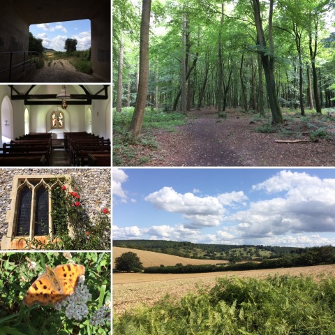
Images from walk on 130819

It was a lovely day, sunny but not as hot as it was when we walked the last stage, and this is a really delightful stretch of path. A lot of it runs through beechwoods, interspersed with fields and occasional flint-and-brick villages. It may not have been as long as some of the sections we've done, but it was definitely the hilliest section, with three major climbs and corresponding descents, and quite steep in places. We stopped for lunch by the preetty little flint church at Pishill (pronounced, I gather, Pies'll), because if there's one thing that I've learnt from all this walking is that if you're in England and want a bench to eat your sandwiches on you're almost certain to find one in a churchyard. Pishill Church was particularly well-equipped, possessing not only a choice of benches but a kettle, mugs and tea and coffee left in the porch for the benefit of thirsty walkers, along with rather good flapjack in return for a suggested donation of 50p per piece. (I'd say "most C of E thing ever", except that on Sunday we went to see the helter-skelter in Norwich Cathedral.) After Pishill, we climbed the hill at Maidensgrove and then descended via the Warburg Nature Reserve to a stretch of road-walking before a final climb from Middle Assendon to cross Henley Park and head down to the town and river.

The end of the Oxfordshire Way isn't commemorated with a plaque or obelisk as better-known trails are; I think the last (or first, depending on your direction) sign is the one pointing off a road on the outskirts of Henley along the path to Henley Park. I don't think it's ever going to be a destination walk, and I probably wouldn't revisit the middle sections, but it's been lovely getting to know Oxfordshire a bit better and the first and last couple of sections were delightful. I wouldn't redo yesterday's walk as a linear walk, but that was mainly because of the awkwardness of the transport links that way; having to get the bus into Oxford and then all the way out again via Headington to Lewknor meant that it took us an hour and a half to get to the start, and the same again to get back via the two changes needed to get from Henley to Oxford by train. I would absolutely do a circular walk on the same paths, though, and as our book of adventurous walks includes one which starts and finishes in Christmas Common and returns via the Oxfordshire Way from Maidensgrove via Pishill, I suspect we definitely will.
white_hart: (Default)
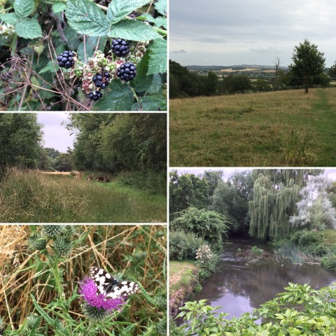
I had today off work as well, so we walked the fifth (and penultimate) stage of the Oxfordshire Way; ten and a half miles from where we left off in Tiddington to the junction with the Ridgeway near Watlington, plus another two and a bit miles down the Ridgeway to Lewknor Turn to pick up the Oxford Tube back to Thornhill park and ride where we'd left the car to save having to travel into Oxford and out again both ways.

Images from walk on 290719

It was a glorious sunny day, but still much cooler than last week with temperatures in the mid-20s and a bit of a breeze. This section was much more interesting than the last couple; although we stopped just short of climbing up into the Chilterns proper, for most of the day we were walking through a gently undulating landscape that seemed to have a clear kinship with the hills ahead. After climbing out of Tiddington through fields (including one with a sign warning of the presence of a bull, though the only animal visible was a black and white cat) we walked through the woods of the Rycote estate and crossed a golf course before descending to the village of Tetsworth and crossing under the M40, then crossing more fields and following a long tree-lined lane into Pyrton. About a mile and half south of Pyrton we turned on to the Ridgeway, which at this point actually turned out to run along the bottom of the Chiltern escarpment, rather than the top. It was a particularly pleasant section, mostly through beech woods (whose shade was very welcome by that point), emerging into open fields as it neared the motorway where we turned downhill again to reach the bus stop.

Unlike the last section, this is one I'd happily walk again, and in fact the public transport links make it very easy (in particular, the trip from Lewknor back to Thornhill is incredibly quick). I'm also looking forward to the next and final section through the Chilterns to reach the Thames at Henley, although the public transport back from that is less good (changes at Twyford and Reading).
white_hart: (Default)
I had the day off work yesterday, and as it was significantly cooler than it had been for the rest of the week (though still quite warm) we decided to tackle the next stage of the Oxfordshire Way, retracing our steps to Islip and then following the Way through Beckley and Waterperry to Tiddington, which straddles the Oxford-Thame-Aylesbury Road and is served by the 280 Oxford-Aylesbury bus which we could catch back to Oxford.

Images from walk on 270719

This and the Kirtlington-Islip section are probably the least interesting bits of the Oxfordshire Way, mostly running across the flattish farmland of the floodplains of the northern Thames tributaries in between the interesting hilly bits of the Cotswolds and Chilterns. The most interesting bit of yesterday's walk was probably the bit around Beckley, where the path crosses the northern end of the low ridge of hills to the east of Oxford (Forest Hill, Shotover, Garsington Hill, Cuddesdon Hill, part of the same lowish ridge that Cumnor Hill, Boar's Hill and Wytham Hill to the west belong to, as well as Folly Hill in Faringdon and Brill just over the Buckinghamshire border; you can see it quite clearly on this topographic map if that's the sort of thing that interests you) with lovely views from either side of the ridge; before that we skirted the Otmoor RSPB reserve, where we didn't see any birds but did see absolute clouds of meadow brown butterflies. After descending the hill from Beckley the rest of the walk was almost entirely flat fields; pleasant enough, but a little dull.

As there wasn't a convenient village to stop in for lunch on this leg of the walk (Beckley was a bit too close to the start, and then we didn't go through any settlements at all until we got to Waterperry, only a couple of miles from the end) we paused to eat our sandwiches in a small wood near Horton-cum-Studley where we spotted three fallow deer grazing on the path. Shortly after this we met a man walking the other way who warned us that he had been chased by bullocks in a field about half an hour away, and showed us the place on the map. I was glad we were forewarned; it turned out that there was quite a large herd of bullocks in a very long (about a mile and a half) narrow field running all the way round the southeastern corner of a wood, and although to start with there was a reasonable path just inside the fringe of the wood, screened by trees but outside the barbed-wire fence enclosing the wood proper, this petered out once the path turned east along the bottom of the wood, at about the same point as the cows spotted us and started running towards us in a definitely intimidating manner, so we decided that the only thing for it was to wriggle under the barbed wire and pick our way along inside the wood until we reached the end of the field; this was definitely the better option, but much slower going than walking along a good path, which is probably why the 16.5 miles took us about an hour longer than we expected. (That also wasn't helped by being held up at one point, shortly after we'd finally finished circumventing the field with the cows, by three medium-large dogs which bounded out of the garden of a house adjacent to the park to bark at us until their owner finally appeared to call them away, grumbling that she couldn't get there any faster and they wouldn't have hurt us anyway. It was not a good day for intimidating animals.)

We certainly won't be doing that bit of the Oxfordshire Way again, in any case; hopefully the next section (which will just get us to the edge of the Chilterns, as far as the intersection with the Ridgeway which we'll need to follow back to Lewknor to catch a bus home) will be better.
white_hart: (Default)
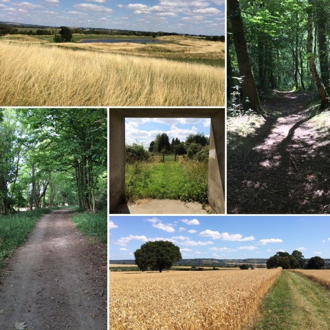
This week, we decided to tackle the next section of the Oxfordshire Way, from where we'd left it at the crossing of the Oxford Canal to Islip. This only got us about 7 miles further on the Oxfordshire Way itself, but worked out as a 15.5 mile walk once we'd added on the five and a bit miles back along the canal to join it and the three miles from Islip back to Oxford Parkway station, where we caught the bus home rather than walking another couple of miles home through Kidlington.

Images from walk on 130719

We walked on Saturday rather than Sunday, because T wanted to be able to spend today watching the cricket. Saturdays seem to be a lot busier than Sundays; we passed several large groups of walkers along the canal towpath and near Kirtlington, though it got quieter after that. With the Cotswolds left behind and the Chilterns to come (though visible in the distance at points in yesterday's walk), the Kirtlington to Islip section of the Oxfordshire Way starts off with a small climb out of the Cherwell Valley into Kirtlington and then descends again to head across parkland and farmland to reach Weston-on-the-Green, adjacent to the A34; it's a fairly flat walk, but the landscape is varied, which made it more interesting than, say, the Thames Path, which I find utterly boring in its sameness. After crossing the A34, we headed through more farmland on what proved to be the worst-maintained section of the path so far; possibly the fact that the post confirming that the darker green line across a field was the turning we were looking for was on its side was simply because haymaking was clearly actively in progress in the field, but we also encountered fields planted very close to the hedges, leaving little space to walk in between, and gates and footbridges choked with brambles and nettles. Finally, we pushed through a very overgrown copse to reach a shiny new bridge over the Oxford-Bicester railway line (the walk directions talk about following the track and crossing with great care, but clearly the upgrading of the line has led to the construction of a bridge for walkers instead) where I only just restrained myself from giving in to the urge to wave at a passing train in a Railway Children-esque manner. After this, there were only a few more fields to cross before we arrived in Islip.

Getting back from Islip was made slightly more difficult by the discovery that the bridleway to Water Eaton, which had looked like the obvious route on the map, involved crossing the Cherwell via a ford which was only really passable if you were on a horse, or possibly wearing waders*. Lacking either horses or waders, we retreated and instead crossed the River Ray at the weir where it joins the Cherwell and followed the east bank of the Cherwell to a bridge near Water Eaton Manor, where we could pick up the bridleway to join the main road near Oxford Parkway.

*To be fair to the map, it was marked as "ford", but I hadn't realised that meant that it might be a ford that wasn't passable on foot. And I'm pleased we discovered this when attempting to walk home *from* Islip, rather than coming the other way, which would have required retracing our steps for a much longer distance.
white_hart: (Default)
We're off to Scotland again at the end of August, heading back to Fort William to pick up where we left off at the end of the West Highland Way and walk the Great Glen Way to Inverness. In preparation for this (and also because we enjoy it anyway) we've been upping our walking distances, and a few weeks ago we also started talking about the possibility of doing a two-day walk with a night in a B&B to help us get back into the habit of doing long walks on consecutive days. At first the plan was to do a two-day walk, getting the train to Moreton-in-Marsh and walking to Charlbury via an overnight stop in Bourton-on-the-Water, but then we looked more closely at the map and measured distances with a bit of string and realised that it would be perfectly possible to walk home from Charlbury in a day via the Oxfordshire Way and the Oxford Canal towpath, so we extended it to a three-day walk. Unlike our normal multi-day walks, for this one we carried everything with us, but it's not as if three days of walking in high summer require that much in the way of luggage (pyjamas, two spare tops, two pairs of pants, two pairs of socks, deodorant, toothbrush) and although I'm still wondering if my new 30l daypack is slightly too big for a day's walking it was the perfect size for a three-day walk, with enough space to add in my walking sandals so I didn't have to spend the evenings in boots.

Day 1: Moreton-in-Marsh to Bourton-on-the-Water via Stow-on-the-Wold )

Day 2: Bourton-on-the-Water to Charlbury )

Day 3: Charlbury to Kidlington )

Generally, this was a really nice walk along well-maintained and well-signposted paths. It was a great way to relax and unwind after another busy term at work, and it was fun to go away with such minimal luggage and not have to make any decisions at all about what to wear. It also demonstrated that, lovely as Scotland is, it's not always necessary to travel a long way to find adventure or get away from things; Moreton-in-Marsh is only a couple of hours away by public transport, even with the rail replacement bus, and only 20 miles from us by road, and yet we managed a fabulous three days of meandering gently back home and might have been hundreds of miles away for all the thought we gave to home, work and normal life.

Profile

white_hart: (Default)
white_hart

May 2025

S M T W T F S
    123
456789 10
11121314151617
18192021222324
25262728293031

Most Popular Tags

Syndicate

RSS Atom

Style Credit

Page generated May. 30th, 2025 04:13 pm
Powered by Dreamwidth Studios